Reported By: | Edited By: Sanjay Jog |Source: DNA |Updated: May 19, 2019, 06:00 AM IST
While the country reels under scorching heat and eagerly awaits the onset of monsoon, DNA interviews Arvind Kumar Srivastava, Climate Research and Services head (Pune), India Meteorological Department, to sail through the crests & troughs of weather forecasts
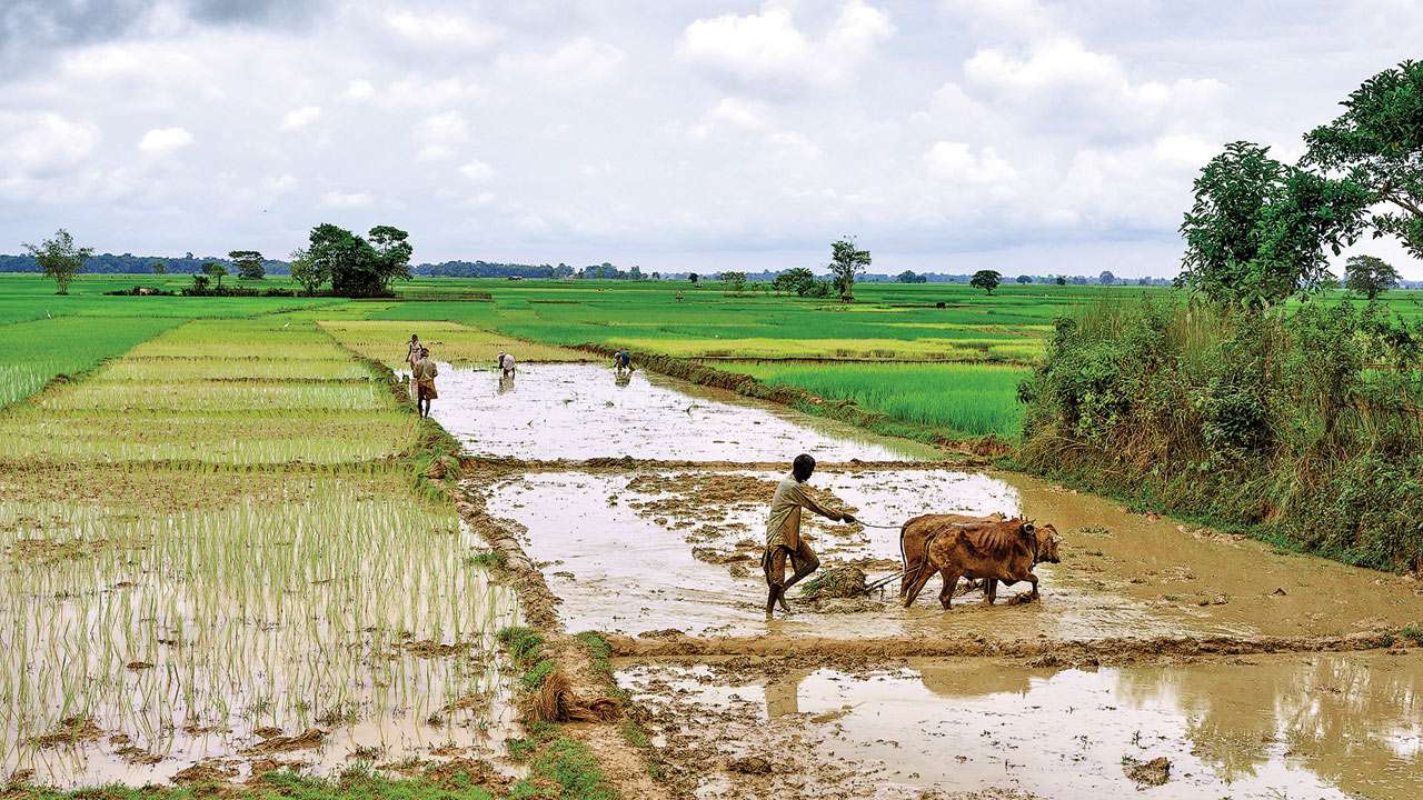
India and its farmers have always been at the mercy of the monsoons. While, as most feel, early predictions can help the farming community reap benefits and save hundreds of lives from natural calamities, an IMD expert talks of the limitations the body faces. Here are excerpts from the interview:
Predictions with regard to the monsoon season is complex. How long does it take? Can you elaborate on what goes on while the country awaits its arrival? Monsoon prediction involves prediction of rainfall for individual monsoon months, as well as overall seasonal rainfall. Rainfall throughout the country and in smaller areas is also predicted. There are two ways of prediction — dynamic and statistical. Dynamic predictions are based on solutions of complex dynamic equations that have no analytical solutions but only numerical solutions. Numerical solutions of dynamic models require high-end computing facility to run the models. Very accurate latest atmospheric and oceanic observations (representing the state of atmosphere and oceans) across the globe are ingested as initial conditions to run the models. For the first stage of forecast, models are run based on atmospheric and oceanic conditions of March and the first ten days of April.
Similarly, for updated rainfall forecast in the last week of May/ first week of June, models are run based on the last three weeks of April and May months' initial conditions. At present, it takes about three days for a single run based on a day's initial conditions. Since, the skill of dynamic models is not precise, up to the very recent past, forecasts were being issued only using statistical models which require identification of parameters and developing appropriate statistical models. Over a period of time, the IMD developed many statistical models and at present the "Project Pursuit" model is being used. To run this model, the IMD has identified a set of eight global parameters (also called predictors).
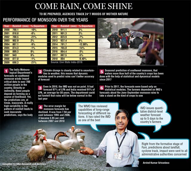
Monsoon covers parts of America, Africa, the Indian subcontinent, and China. Indian monsoon gets moisture-laden currents from both the Arabian Sea and the Bay of Bengal. That apart, sea surface temperatures and the systems over the Pacific Ocean significantly impact the season. Transient waves of the extra tropical mean circulation also influence monsoons in India. While statistical models are developed in-house, dynamic models are taken from other leading climate prediction centres like the NCEP NOAA USA, UK Met office model and so on. However, before adopting these models, a lot of research for improvement in skill is done.
If we see, these controversies are not raised by the experts or scientists working in the field. I can only say that the IMD is in this field for quite some time and has the required amount of expertise. The first-ever long-range prediction (in the world) for monsoon, issued by the IMD, was in 1886. I would like to emphasise that some two years ago, the World Meteorological Organisation (WMO) has reviewed capabilities of long-range forecasting of different nations. It has rated the IMD's monsoon forecasting capabilities as one of the best.
The expeditions to Antarctica are basically meant to collect surface and upper air data over the region to study ozone hole (reported there) phenomenon and assess climate change. The impact of Antarctica's climate on Indian monsoon needs more data and rigorous studying.
Rainfall prediction in Mumbai or Chennai suffers from short-range problems. These events of rainfall (amount-wise) cannot be predicted accurately in advance. The IMD has been issuing extended-range prediction too. These predictions are available four weeks in advance, wherein it is only possible to indicate an occurence. However, the quantum of rainfall can only be accurately predicted some two days in advance. As far as Mumbai's rainfall is concerned, extreme amounts of rain cannot be predicted (as of now), not even 24 hours in advance. Only Nowcasting (forecasts with three-hour-long lead time) may help in such cases. For the same, continuous observations from Doppler radar are required. The IMD has installed Doppler radars in many places and is in process of procuring and installing these at other places too.
This coordination is the outcome of concerted efforts over a long period of time. Right from the formative stage of the cyclone, prediction of the landfall and the cyclone track (route) and its probable impact at the place of landfall (by indicating extreme sustained wind speed and intensity of rainfall) were sent to all administrative authorities concerned like the Chief Secretary, Relief Commissioner, District Collector, and so on. This information is updated periodically (at an interval of three hours and at times even at an interval of half an hour). This information is also sent to the National Disaster Management Authority. Thus, the IMD was able to indicate the landfall and the severity of the cyclone quiet accurately, around a week ago. That said, concerned authorities had sufficient lead time to move people to safer places.
Monsoons over the past years have indicated no significant trend. However, multi-decadal (30-40 years) epochal characters in the monsoon rainfall have been observed. There were epochs of high and low rainfall in the past and these are parts of climate variability. As far as the onset of monsoon is concerned, in Kerala it takes place on June 1. Its variability stretches for 7 days. Thus, monsoon can reach Kerala between May 24 and June 8 and this is quite normal. The season advances in phases... therefore, some sluggishness in its advancement is natural.
The IMD under the Ministry of Earth Sciences (MoES) implemented an operational Agrometeorological Advisory Service (AAS) viz., "Gramin Krishi Mausam Sewa (GKMS)" scheme for the benefit of the farming community in the country. The AAS rendered by the IMD is a step to weather-based crop and livestock management strategies and operations dedicated to enhancing crop production and food security besides reducing crop damage and loss due to extreme weather events. The IMD is issuing quantitative district-level weather forecast up to five days and the products comprising quantitative forecasts have seven weather parameters; rainfall, maximum temperature, minimum temperature, wind speed, wind direction, relative humidity, and cloudiness. In addition, the weekly cumulative rainfall forecast is also provided. Based on the weather forecast, Agromet Advisories are prepared in collaboration with 130 Agromet Field Units located at State Agricultural Universities (SAUs), institutes of Indian Council of Agriculture Research (ICAR), Indian Institute of Technology (IITs) etc. twice a week (Tuesday and Friday) and communicated to the farming community via multi-channel dissemination systems.
Also Read: In cloud-cuckoo land: Birds, frogs, flying ants predict rains