It is very likely to maintain the intensity of a Super Cyclonic Storm till Monday evening and weaken gradually thereafter.
Cyclone 'Kyarr', which intensified into a 'Super Cyclonic Storm' with a wind speed of close to 250 kmph, is gradually slowing down as it moves towards the coast of Oman with a speed of 13 Kmph, IMD said on Monday.
The cyclone brought light to moderate rainfall at a few places over coastal districts of Maharashtra, Goa and North Karnataka on Sunday before moving away over Eastcentral Arabian Sea.
It has now created a low-pressure area over the equatorial Indian Ocean off south Sri Lanka coast which would bring light to moderate rainfall over south Kerala and south Tamil Nadu, the IMD said in a bulletin.
"Light to moderate rainfall at most places with heavy falls at isolated places likely over south Kerala and south Tamil Nadu during next 3 days and very heavy falls at isolated places also likely over south Kerala and south Tamil Nadu on 29th and 30th October," the Indian Meteorological Department said.
The IMD also warned of very heavy falls at isolated places on Tuesday and extremely heavy falls at isolated places on Wednesday over Lakshadweep area.
The weather forecast agency also warned of "strong wind speed reaching 20-30 kmph gusting to 40 kmph over equatorial Indian Ocean and adjoining southwest Bay of Bengal off south Sri Lanka coast on Monday, wind speed reaching 30-40 kmph gusting to 50 kmph likely to prevail over Comorin area and neighbourhood on Tuesday and Squally wind speed reaching 40-50 kmph gusting to 60 kmph likely to prevail over southeast Arabian Sea and adjoining Lakshadweep-Maldives areas on Wednesday and Thursday."
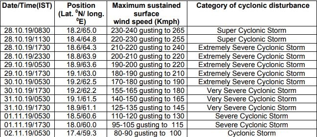
The IMD in an update at 2:30 pm, Monday said that at 11:30 am the cyclone lay over Eastcentral Arabian Sea, about 830 km west-southwest of Mumbai, 1160 km east-northeast and 690 km east-southeast of Salalah and Masirah coasts of Oman, respectively.
"It is very likely to move west-northwestwards till October 30, recurve west-southwestwards thereafter and move towards the Gulf of Aden off south Oman-Yemen coasts during subsequent 3 days," the IMD said.
It is very likely to maintain the intensity of a 'Super Cyclonic Storm' till Monday evening and weaken gradually thereafter.
The weather department has said that sea condition will be phenomenal over east-central Arabian Sea around the till Wednesday and will become High to very High during the subsequent 48 hours.
"Gale wind, speed reaching 230-240 kmph gusting to 265 kmph, is prevailing around the system centre over eastcentral and adjoining westcentral Arabian Sea. It is very likely to reduce gradually becoming 190-200 kmph gusting to 220 kmph by October 29 morning and 110-120 gusting to 130 kmph by November 1 morning," IMD said in its cyclone update.
In a warning to fishermen, the IMD said they are advised not to venture into eastcentral Arabian Sea till October 29 and into west central Arabian Sea from October 28 to November 1.


 "Cyclone Kyarr over Eastcentral Arabian Sea")
)
)
)
)
)
)
)
)
)
)
)
)
)
)


)
)
)
)
)
)