Reported By: | Edited By: V Subramanyan |Source: DNA webdesk |Updated: May 14, 2015, 08:21 PM IST
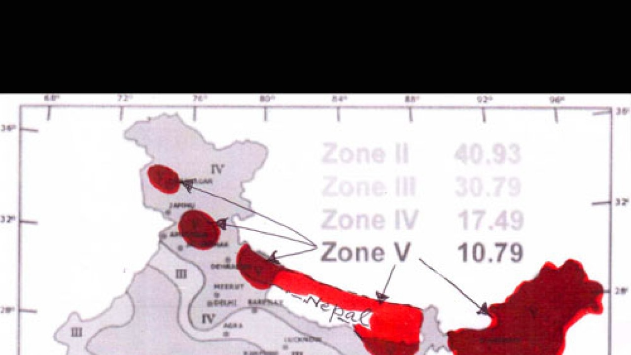
Quite clearly, nature is not giving the Himalayan Kingdom any respite, 81 years after the last major earthquake in the region - the ‘North Bihar-Nepal Earthquake’ of 1934. In the Seismic Zones Map of India of 1972, which is currently being followed (with a modification), Nepal falls in Zone 5 (See Picture). All the places located in Zone 5 carry the tag of a Magnitude 8 earthquake. So the 7.9 Magnitude earthquake that struck Nepal at Lamjung, 77 km to the northwest of Kathmandu on April 25 only validated the seismic zoning. It will be seen from the portion of the map presented that there are five disconnected ’islands’ of Zone 5, occurring on the base of Zone 4, from Kashmir to the northeastern states, all of which constitute the largest region of Zone 5.
Seismicity of the Himalayan Region and Nepal
The high seismicity of the sub-Himalayan arc is attributed to the slow northerly movement of the Indian ‘tectonic’ plate at rates ranging between 48 mm and 53 mm per year, in its attempt to get thrust under the continental massif to the north - the Tibetan Plateau in the case of Nepal. This is called ‘subduction’ in Plate Tectonics and results in a massive collision of two opposing continental blocks, leading to the release of earthquake energy through the already-existing weak planes in the rocks of the region that go by the name ‘thrust faults’. Three such features have been mapped all along the sub-Himalayan region, namely, the Main Frontal Thrust (MFT), the Main Boundary Thrust (MBT) and the Main Central Thrust (MCT). Any one of them is capable of acting as the conduit for the release of earthquake energy.Considering the occurrence of a second earthquake of Magnitude 7.3 on May 12 epicentred 78 km west of the town of Namche Bazaar near Mt. Everest and northeast of Kathmandu, it would appear that both these quakes have been brought about by the activation of the Main Central Thrust. Only detailed geological investigations will throw light on this aspect.
Aftershocks
During earthquakes, enormous pressure that has been accumulating in the rocks of the earth’s crust for a long time gets released suddenly, and so it often happens that the entire quantum does not come out at one go but some residual part gets released slowly over a long period which may be a few days, months or even years. This can be understood from the behaviour of a specimen of rock that is compressed in a machine. It will contract substantially to start with, but will do so only slowly as time passes. If the application of pressure is stopped, it will expand fast initially but will gain in volume only slowly afterwards. The aftershocks were there for both the earthquakes on April 25 and May 12.
Buildings in Nepal
From what can be seen in the visuals of the damage due to the earthquakes in Nepal, it looks as though most of the buildings were brick-and-mortar structures without much of cement and they had all collapsed. Richard Sharpe, a leading earthquake engineer from New Zealand, who had reportedly drafted the building codes for Nepal in 1994 after spending 18 months, has lamented that “the earthquakes that jolted Nepal could have been far less destructive had building codes been adhered to”. That says it all eloquently -- to keep the cost down, the safety of the buildings appears to have been compromised.
The author is former Professor of Geology, IIT Bombay